• Skip to primary navigation
  • Skip to main content

The Tevis Cup

100 Miles - 1 Day - Trail Ride

  • THE RIDE
    • Ride Day Links
    • 2025 Ride
      • Entering The Ride
      • Preliminary Entrant List
    • Planning for the Ride
      • Ride Dates
      • Rider Resources
      • Vet Check Maps
      • Checkpoint Locations and History
    • Crews and Spectators
      • Where to Watch?
      • Crew Guide
      • Checkpoint Locations and History
    • Volunteering
    • Historical
      • RESULTS (1955-present)
      • Buckle Recipients
      • Past Cup Winners
      • Facts and Figures
      • Tevis Forums
      • Videos
    • Tevis Photographers
    • Flickr Photos
    • Tevis Facebook
    • Tevis YouTube Channel
    • Sponsors
    • Rules & Policies
  • THE TRAIL
    • The Trail
    • Checkpoint Locations and History
    • Videos of the Tevis Ride and the Western States Trail
    • Tevis Trail FAQ
    • Vet Check Maps
    • Pre-Riding the Tevis Trail
    • Trailwork Days Sign Up
    • How to Help with Trail Maintenance
    • Granite Chief Wilderness – Trail Reroute
  • EDUCATION AND TRAINING
    • Virtual Tevis Cup 2025
    • Trail to the Trail
    • Tevis Training Ride Weekend
      • Tevis Training Ride 2025 Entry
      • Tevis Training Ride 2025 – Entrants
    • Educational Videos
    • You Can Do It!
    • Sweat – and How to Save It
  • WSTF
    • WSTF Board
    • Dru Barner Award
    • Annual Reports
    • Equine Welfare Studies
    • Tevis Forums
    • Where Does All the Money Go?
    • Rules & Policies
    • Copyright Information
    • Contact Us
  • DONATE
  • TEVIS STORE
  • PAST POSTS
  • Show Search
Hide Search

Mosquito Fire

September 7, 2022

We are carefully monitoring the Mosquito Fire that started in the canyon at Oxbow Reservoir below Michigan Bluff around 6 pm on Tuesday, September 6th and burned north, upslope across Gorman Ranch Road overnight.

As of 4 pm on September 7th (Wednesday), the fire was at 4,223 acres and more or less doubled in size from the previous 6 hours. More updated information can be found at YubaNet.Com.

Map of the fire perimeter/activity can be found at #FireMappers.

Evacuations are in place for Michigan Bluff and surrounding communities, as well as much of Foresthill. Areas west of Foresthill and south of the Middle Fork of the American River are under evacuation warning.

As of Wednesday, the fire is currently actively burning in the vicinity of Michigan Bluff and Chicken Hawk. We are greatly saddened by all affected by this fire, as well as the Western States Trail in the Volcano Canyon, Chicken Hawk, Michigan Bluff and El Dorado Canyon areas.

This fire has impacted many of our WST friends very directly and we hope that they will reach out to the Tevis Family if they need any help.

Fire perimeter as of 4 pm on Wednesday, September 7th
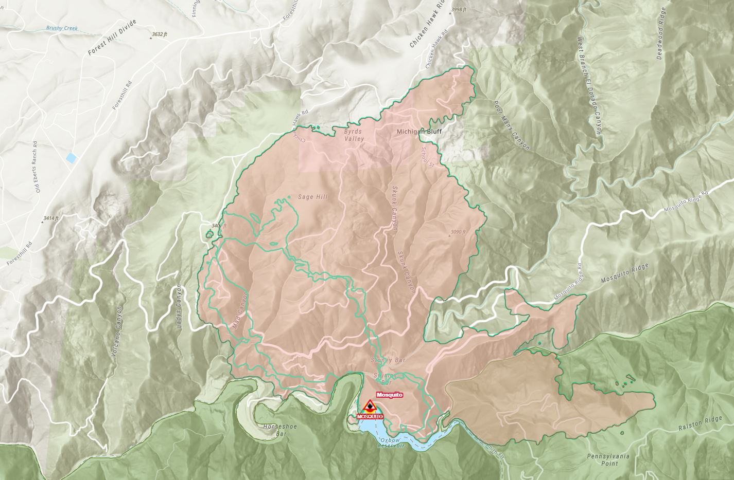
Source: #FireMappers

2022, News

TEVIS QUICK LINKS

The Ride
The Ride
Ride Entry
Rider Resources
The Trail
WST Map
Volunteering
Trail Work Sign Up
Education & Training
Educational Events 2025
Virtual Tevis Cup
Bits and Bobs
Archives
Sponsors
Vendor Registration
Contact Us
WSTF@teviscup.org
(530) 823-7282

The Tevis Cup

Copyright © 2025 · Log in