Pre-Riding the Tevis Trail
Trail Closure – First Few Miles of CA Loop
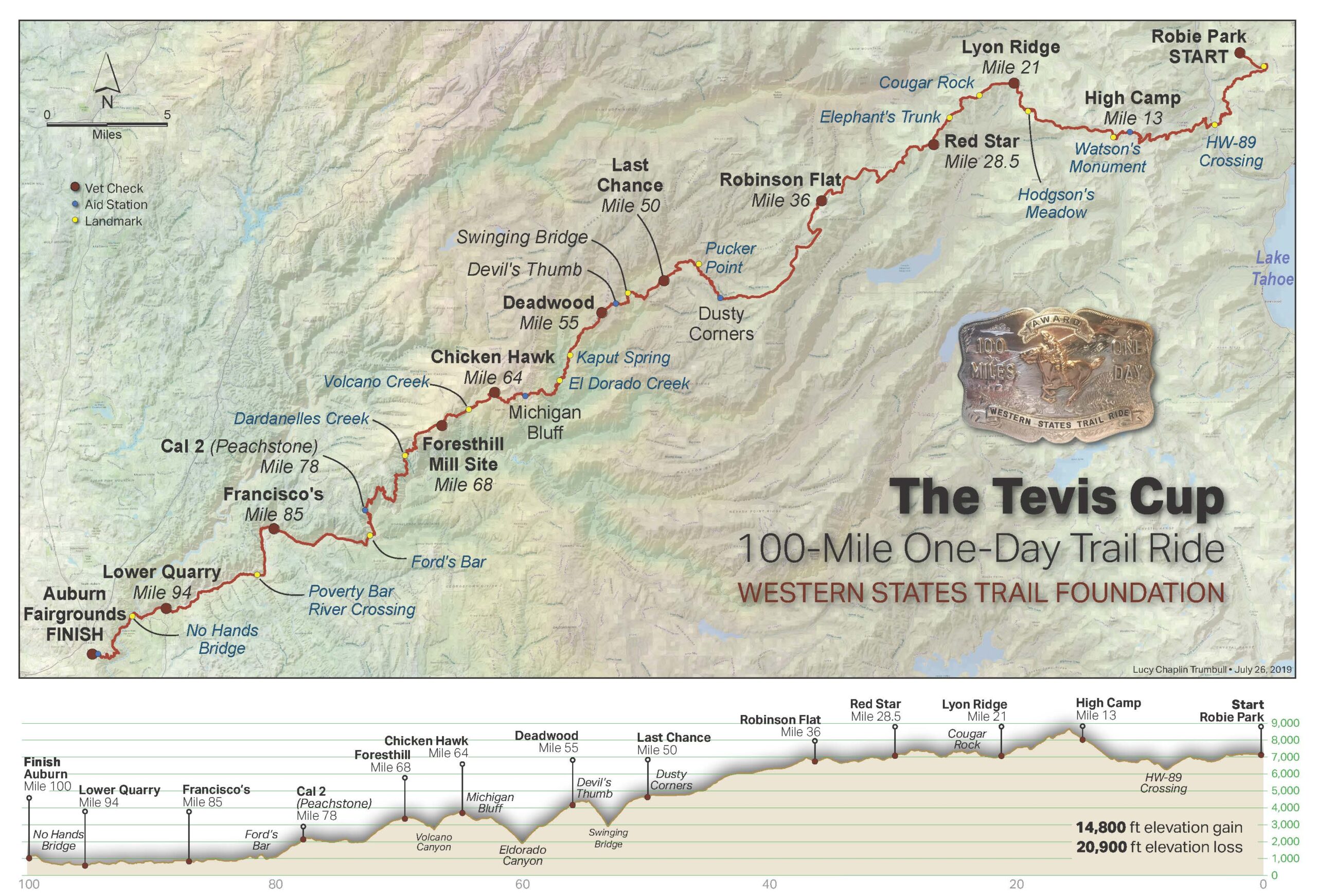
Currently the trail is closed for the first few miles after you leave Foresthill riding towards Francisco’s due to being on private property (it will be open for ride day).
What are the best places to park my horse trailer to pre-ride parts of the Western States Trail on my own?
There are several good places to park, tack up and ride the WS Trail. Starting with the Finish Line and working back up the trail to the more remote sections, they are as follows:
- The Auburn Overlook Equestrian Staging Area is directly adjacent to the Tevis Finish Line location on Pacific Avenue, just south of the WSTF Office on Gum Lane. Use the gravel parking lot alongside the canal, not the paved one next door for the Skate Park. You will need a Poppy Pass or to pay a parking fee.
- Highway 49 Crossing: Although it is possible to access the trail where it crosses Highway 49, near the American River North Fork/Middle Fork Confluence (near No Hands Bridge), owing to the huge popularity of this area in the summer it is unlikely that you’ll find space to park a rig. When the weather is cooler or on week days you may be lucky.
- Driver’s Flat is a quarter mile off the Foresthill Road, about half way to Foresthill, and has good parking. The Driver’s Flat turnoff is well marked. From the trailhead, it is about a 30 minute ride down to Francisco’s at the river. Once on the trail, you have the option of heading east towards Foresthill, or downriver towards Poverty Bar. Beware of high water at the river crossing and use extreme caution if you opt to cross. Mornings are best, as the river level is raised later in the day. You will need a Poppy Pass or to pay a parking fee.
- Foresthill
- To ride the trail eastwards, towards Michigan Bluff, you can park in front of the cemetery across the street from the old mill site (Foresthill Vet Check) at the east end of town. To access the trail, take Bath Rd until the paved road makes a sharp turn to the right – the trail is straight ahead, through the metal bar gate.
- To ride the trail westwards, towards Francisco’s: Currently the trail is closed for the first few miles after you leave Foresthill due to being on private property (it will be open for ride day).
you can also park at the cemetery and ride through town on the paved frontage road. Turn left (south) onto California Street, and then right (west) onto Lowe Street. You can also park on the verge on Lowe Street but please be respectful of local residents, take care not to block any driveways, and clean up your manure. Follow Lowe Street west, around to the corner to the left and to the end drop down the bank and cross Mosquito Ridge Road to access the trail.
- Michigan Bluff: The turn off to Michigan Bluff is 3 miles past the end of Bath Road (leaving Foresthill). Use caution as it is a twisty road and quite steep in sections. You can park on the grass shoulder in the middle of town. Please be respectful of local residents and donʻt block driveways. To ride towards Chicken Hawk, take Gorman Ranch Road; to ride towards Deadwood, turn left at the end of the residential main street, follow the track around the gate, and look for the trail sign. Note: Trails east of Michigan Bluff usually inaccessible due to snow from about November until late May/early June.
- Chicken Hawk: From Foresthill Road, turn onto Michigan Bluff Road and travel 2 miles to a right turn – this is the 0.6-mile dirt road that leads to Chicken Hawk Staging Area. Horse camping is encouraged here during the summer and there is a newly-installed pit toilet. Although there is a well at this location, the infrastructure needed to extract the water needs to be brought in by special arrangement, so please bring your own horse water. From here you can ride the trail east towards Michigan Bluff, or west through Volcano Canyon and on to Foresthill. (Note: beware that google maps will send you to another part of Chicken Hawk Rd, far away from the actual staging area).
- Deadwood/Devil’s Thumb: Further along Foresthill Road, just past Mumford Bar Staging Area, you can turn right onto Deadwood Road which is dirt and can be very rough. At 6.5 miles there is a left turn which will take you to Devil’s Thumb, or you can continue straight another mile to the pump at Deadwood. The road is not recommended for low-clearance vehicles, so use common sense if you want to stage from here.
- Robinson Flat: From Foresthill, follow Foresthill Road 26 miles (about 45 minutes) to the campground. There are pit toilets at this location, and although there is a pump in the meadow (no horses allowed please), it may not be operational, so don’t rely on it. From here you can ride the trail east along Soda Springs Road to Red Star Vet Check – and make a day trip to Cougar Rock and back; or west to pre-ride the canyons by riding to Foresthill – 32 miles. For a scenic ride, head south on the old Tevis trail down into Duncan Canyon, or take the Little Bald Mountain Loop which passes close to the Bald Mountain Lookout. The fire lookout will often welcome a visit to the tower for amazing views towards Lyon Ridge, Red Star Ridge, and west to Foresthill.
- Palisades Tahoe Olympic Valley (Formerly Squaw Valley): Currently the ski resort area is under construction, so for your safety, please avoid riding there until further notice.
- HW-89 Crossing: There is a small turnout on the west side of hw-89 where the Tevis trail crosses under the bridge, large enough to park a couple of rigs. From here you can either ride the trail backwards towards Robie Park (there’s a nice loop on the Tahoe Rim Trail towards Watson Lake and on to Robie Park and back on the Tevis Trail); or you can head west towards Olympic Valley.
- Robie Park: In the summer you may stage or camp at Robie Park. Access is on Mount Watson Blvd, off Brockway Summit on hw-267.