Click on the triangles to open each section:
How has the trail changed, if at all?
For the most part, the route is as it was in 1955. The Trail still goes from the Lake Tahoe Area to Auburn, but the years of population growth in the Sierra have taken their toll and certain route modifications had to be made.
The Ride originally started at the Tahoe City Community Center, literally at the shoreline of Lake Tahoe.
In 1970, the starting line was moved to Olympic Valley (formerly Squaw Valley), a few miles away, where it remained for the next 20 years. The only exception was in 1983, when the ride began at Soda Springs (Serene Lake). Emigrant Pass was still closed that year due to an unusual late Spring snow,
The section of trail known as the California Loop, from California Street in Foresthill to the vet check at Francisco’s, was first used in 1982. It replaced the route through Todd Valley Estates, which was rapidly being developed with new homes and paved roads at the time.
In 1990, the starting line was moved to its current location at the newly-established Robie Park, north of Tahoe City. In order to retain the 100-mile Ride length, the leg that ran along Red Star Ridge and back through Duncan Canyon into Robinson Flat was dropped in favor of the present, more direct route along the Soda Springs Forest Service Road. The 1990 Ride was probably the toughest of all because of the unknowns involved with the route changes. Temperatures on the trail that day were also the hottest in the Ride’s history. Hal V. Hall was first to finish that year, with a completion time of 15:56, the longest first place finish in the Ride’s history.
The 1997 Ride route included a temporary change. The original Western States Trail through Todd Valley was used by connecting from “Cal 2” to White Oak Flat. The vet check, usually held at Francisco’s, was moved up hill to White Oak Flat. Riders then rode down to rejoin the usual route toward the Poverty Bar river crossing.
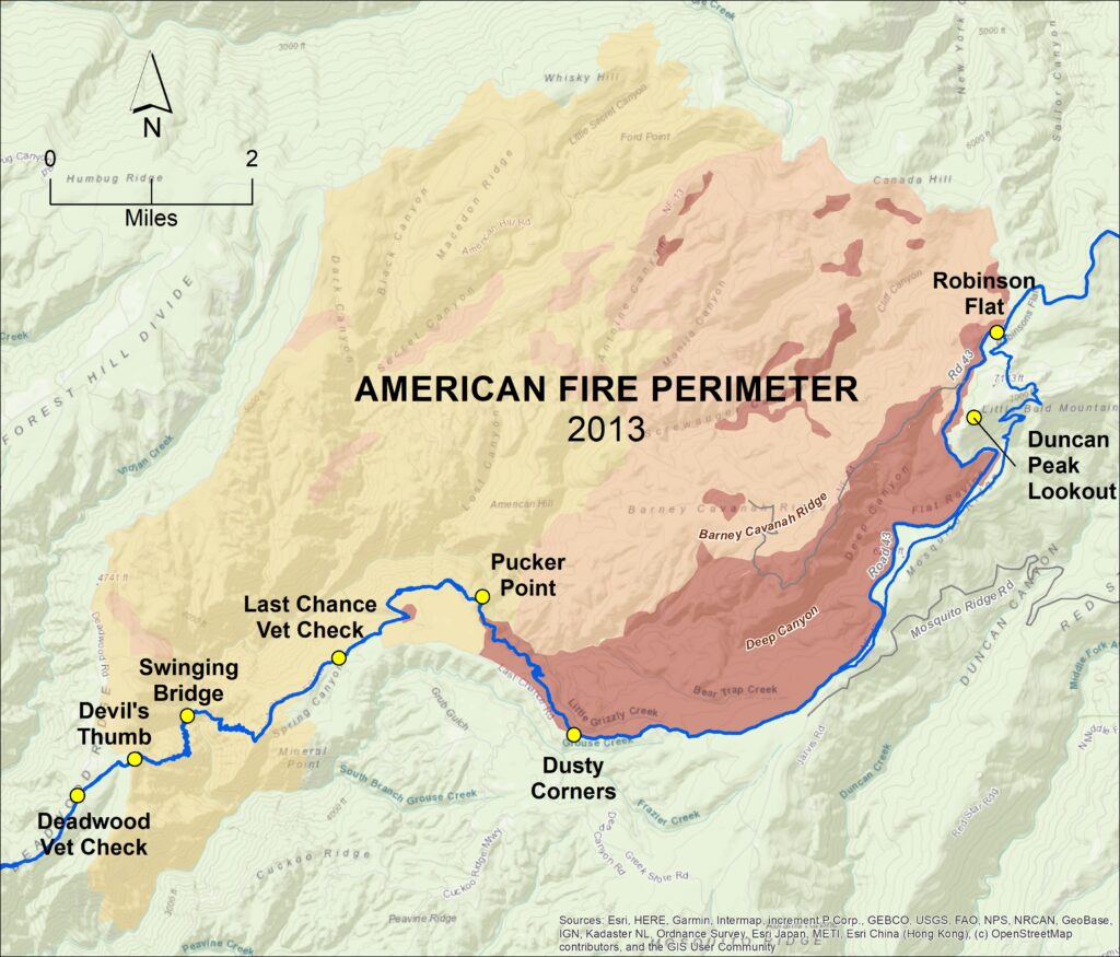
The 1998 Ride route added a scenic stretch of single track between Dusty Corners and Last Chance, now known as “Pucker Point” for its breathtaking viewpoint above the Deep Canyon gorge. However the difficulty of maintaining this trail after the devastating American Fire in 2013 and resulting erosion has meant that in recent years the Ride has need to by-pass this trail for safety reasons.

The 2003 Ride initiated the most recent major change to the trail. After departing Robinson Flat, the course used to follow Cavanaugh Ridge, a rocky single track stretch of several miles. Riders would then cross the Deep Canyon area following a Forest Service road to reach Dusty Corners. Now the course bypasses Cavanaugh Ridge by continuing on FS Road 43 out of Robinson Flat and then following a single track trail with good footing to reach Dusty Corners. The distances involved remain the same, but riders can make better time on the new route.
In 2011 late snows forced the last-minute postponement of the ride (it was snowing at Robie Park a few days before the start of the ride), and a modified Auburn > Michigan Bluff > Auburn ride was held in October.
Following the American Fire, in 2014 the Ride was unable to use the burned, but not yet rebuilt Swinging Bridge, so riders had to forge the belly-deep river below. Thankfully, due to the tireless efforts of work crews, the Pacific Slab Bridge (which had been completely burned) on the Last Chance side of the canyon was reconstructed from scratch using hand-carried lumber, and the eroded trail further down the canyon meticulously refurbished.
In 2017 the ride was again started at Soda Springs (Lake Van Norden) due to the depth of the snow in Granite Chief Wilderness. The modified route rejoined the normal trail at Lyon Ridge trot-by, continued along to Red Star Ridge Vet Check (which was moved about a mile to the southeast) before detouring onto the pre-1990 trail along Red Star Ridge and through Duncan Canyon and up to Robinson Flat.
The next step in the trail evolution will be the rerouting of the Granite Chief Wilderness trail, expected to be completed by the end of the summer of 2024.
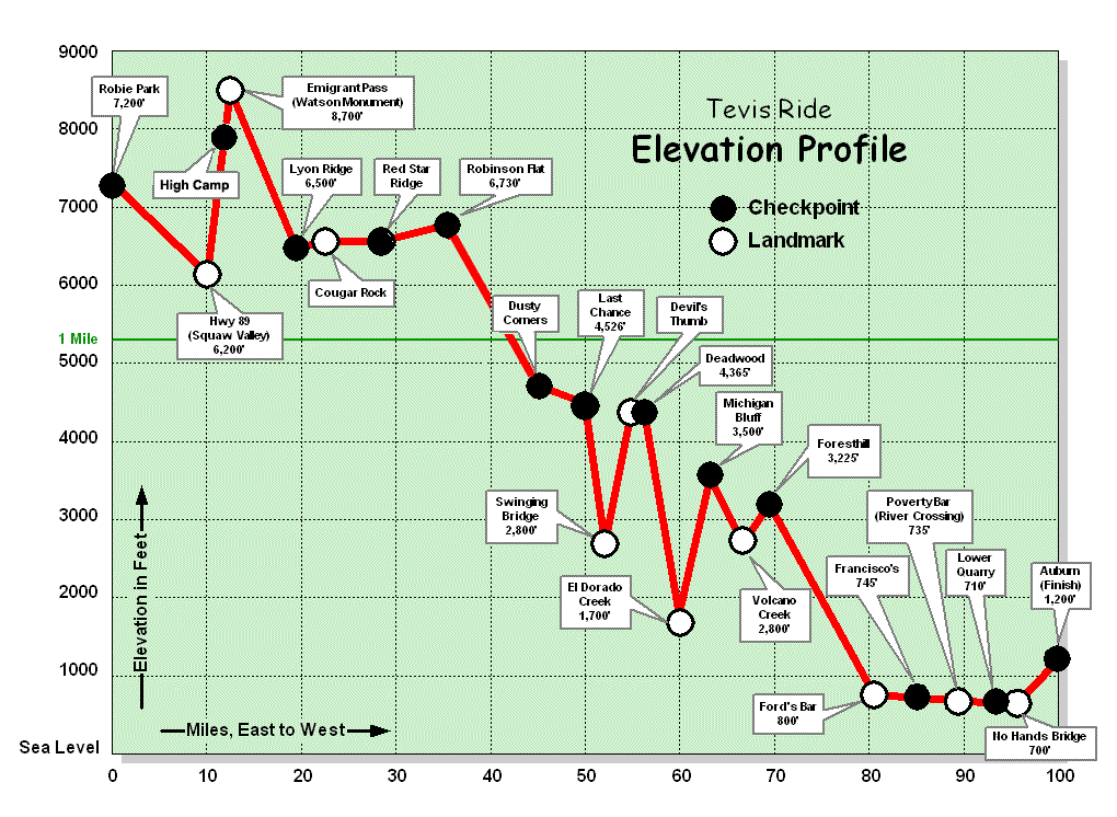
It is said that the Ride has 19,000 feet of “up” and 22,000 feet of “down” – is this true?
Pretty close. When the ride used to start at Olympic Valley (formerly Squaw Valley) the numbers were 17,040 feet of climbing (about 5,194 meters) and 21,970 feet of descent (about 6,696 meters). Now that the starting line has moved to Robie Park, the overall elevation numbers are probably about the same, but new exact numbers have not been computed.

Will my horse and I have to swim to get across the American River?
No. Placer County Water Agency, operator of the dams upstream of the crossing, hold back much of the normal flow of water, starting the morning of the ride. By the time the first horses arrive at the crossing the water is at a low level and you don’t have to swim. Because the Ride is held in late July/early August, heavy Spring snowmelt is usually not a problem. The Western States 100 Mile Run, on the other hand, is held the last weekend of June and several times has had to use rafts to get the runners across safely. Note: When pre-riding the trail in the weeks before the ride, use common sense and take great care crossing the river. The middle fork of the American river has become a popular destination for commercial white water rafting, and the water agency often increases water output on the weekends for this very reason. Water levels are usually lowest and therefore passable before mid-morning.