• Skip to primary navigation
  • Skip to main content

The Tevis Cup

100 Miles - 1 Day - Trail Ride

  • THE RIDE
    • Ride Day Links
    • 2025 Ride
      • Entering The Ride
      • Preliminary Entrant List
    • Planning for the Ride
      • Ride Dates
      • Rider Resources
      • Vet Check Maps
      • Checkpoint Locations and History
    • Crews and Spectators
      • Where to Watch?
      • Crew Guide
      • Checkpoint Locations and History
    • Volunteering
    • Historical
      • RESULTS (1955-present)
      • Buckle Recipients
      • Past Cup Winners
      • Facts and Figures
      • Tevis Forums
      • Videos
    • Tevis Photographers
    • Flickr Photos
    • Tevis Facebook
    • Tevis YouTube Channel
    • Sponsors
    • Rules & Policies
  • THE TRAIL
    • The Trail
    • Checkpoint Locations and History
    • Videos of the Tevis Ride and the Western States Trail
    • Tevis Trail FAQ
    • Vet Check Maps
    • Pre-Riding the Tevis Trail
    • Trailwork Days Sign Up
    • How to Help with Trail Maintenance
    • Granite Chief Wilderness – Trail Reroute
  • EDUCATION AND TRAINING
    • Virtual Tevis Cup 2025
    • Trail to the Trail
    • Tevis Training Ride Weekend
      • Tevis Training Ride 2025 Entry
      • Tevis Training Ride 2025 – Entrants
    • Educational Videos
    • You Can Do It!
    • Sweat – and How to Save It
  • WSTF
    • WSTF Board
    • Dru Barner Award
    • Annual Reports
    • Equine Welfare Studies
    • Tevis Forums
    • Where Does All the Money Go?
    • Rules & Policies
    • Copyright Information
    • Contact Us
  • DONATE
  • TEVIS STORE
  • PAST POSTS
  • Show Search
Hide Search

Robinson Flat

A well-earned hour-hold awaits you at Robinson Flat vet check (6,730 ft)
There are few places along the trail to really move out, but the Soda Springs Road between Red Star Ridge and Robinson Flat is one of them. If your horse is feeling fresh, you can make good time along here and gobble up this stretch in an hour. By the time you arrive, you are more than ready for a break.  Robinson Flat is the first place along the trail that crews are allowed and they line the dirt road for several hundred feet as you arrive, anxiously watching to catch a glimpse of their rider - equipped with buckets and sponges, wheeled carts, feed bags, and almost every accoutrement an endurance mount might need.  Your hour-hold starts once you hit the pulse criteria of 60, so getting tack stripped and the horses cooled down as quickly as possible is the order of the day. Once that is achieved, you quickly vet through helped by a slew of vets. Now you can settle your mount in front of a smorgasbord of food and clean up the filthy rider. Enjoy this respite - it’ll be over before you know it and it’ll be time to mount up again. Ride lore has it that you shouldn’t arrive at Robinson Flat in the  top ten, or risk an early pull.

History of Robinson Flat:

Once a meeting place for indigenous tribes, Robinson Flat later became a trail crossing and served as a resting place with forage in the natural meadow for livestock of the early-day traveler. From 1913 to 1971 Robinson Flat was the summer home of US Forest Service patrolmen who protected this part of the Tahoe National Forest. In the grassy meadow of Robinson Flat there is a pitcher pump that provides cold potable water near a large granite stone with an inscription that dedicates Robinson Flat as the “Crossroads of the Sierra.” Also, there is a kiosk for those interested in the trail conditions and information (as well as pit toilets in the campground). The Foresthill Ranger District of the Tahoe National Forest administers the Robinson Flat Campground.

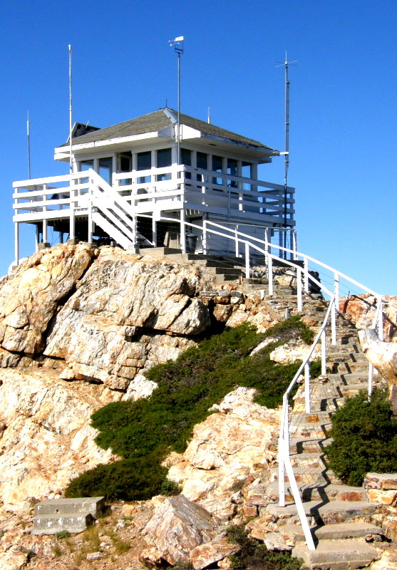
A mile to the south, sitting atop a high cone-like mass of white granite is the Duncan Peak Lookout, at 7,182 ft elevation, which has observation of much of the central Sierras. Accessible by road, the lookout is a source of spectacular panoramic views of the high crest of the Sierra to the eat and the Coast Range to the west, including Sacrament and San Joaquin Valleys.

Duncan Peak Lookout

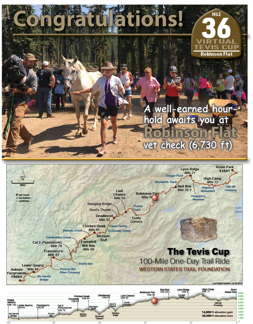
Robinson Flat Vet Check:

This is a very “lively” vet check filled with crews and spectators on normal years. Riders/Crews will receive a vehicle parking pass which allows them to drop their supplies at the turn around point and then transport (bring a wagon!) their gear to the chosen crewing area. The past several years, the main vetting area has been closed by the USFS due to hazard trees so we’ve been using a clearing for the vetting area. This has limited crews access to only 2 individuals per rider and no spectators. During a non-limited year, spectators can park at Sailor Flat and then catch the shuttle bus up to Robinson Flat to view the incoming horse and rider teams.

2014 Vet Check at the traditional location

On June 19th to 24th 2016, the American Trail Running Association partnered with the Google Maps team to capture 360 degree panoramic “street-view” imagery of the entire Western States Trail using the Street View Trekker backpack:
Robinson Flat

TEVIS QUICK LINKS

The Ride
The Ride
Ride Entry
Rider Resources
The Trail
WST Map
Volunteering
Trail Work Sign Up
Education & Training
Educational Events 2025
Virtual Tevis Cup
Bits and Bobs
Archives
Sponsors
Vendor Registration
Contact Us
WSTF@teviscup.org
(530) 823-7282

The Tevis Cup

Copyright © 2025 · Log in